
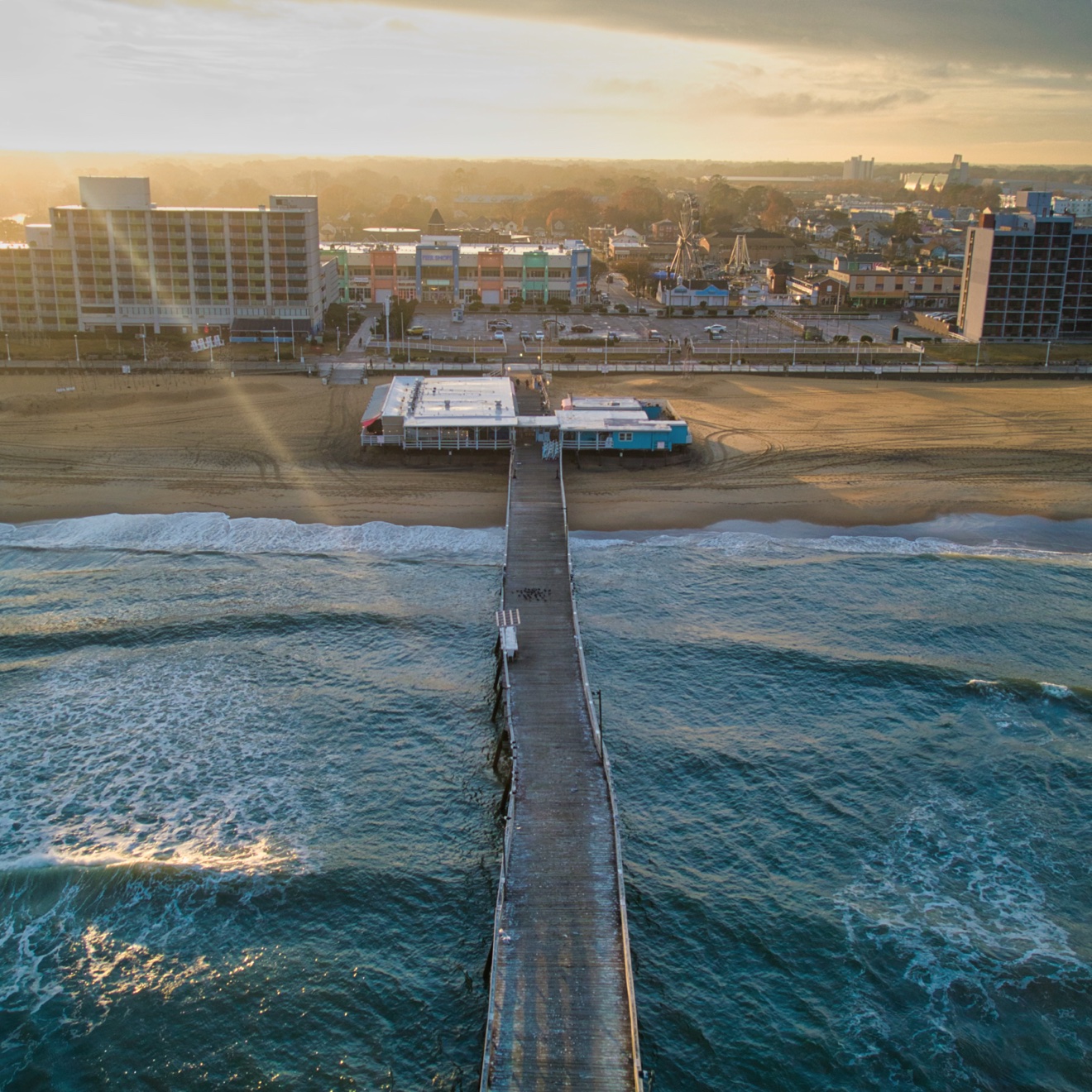
From the beach, Virginia Beach looks like a drone pilot's dream: 35 miles of coastline, open ocean, wide resort streets, the Chesapeake Bay, Back Bay marshes, and a working waterfront. From the sectional chart, it is something else entirely — a patchwork of Navy controlled airspace, restricted areas, and training routes where F/A-18 Super Hornets fly daily patterns at low altitude.
That gap between how the place looks and how its airspace works is where productions get in trouble. A location scout sees a perfect establishing shot. A pilot who actually flies here sees a 0-foot UAS Facility Map grid, a Class D boundary that starts at the surface, and a tower that will not approve a flight just because a city permit was signed.
Four installations shape every flight in Virginia Beach
Virginia Beach is a Navy town. Three major installations sit inside or directly on its borders, and a fourth — in Chesapeake — extends its reach across the southern half of the city. Each one controls airspace differently, and a production that treats them as a single "military zone" will misread every grid square on the map.
Naval Air Station Oceana (KNTU) — Class D, surface to 2,500 ft
The East Coast master jet base — home to the Navy's strike fighter squadrons flying the F/A-18E/F Super Hornet. Oceana's Class D airspace covers a roughly 4.3-mile radius around Apollo Soucek Field. Inside that boundary, no commercial drone flies without FAA authorization coordinated with air traffic control. Much of the resort area's southern half and neighborhoods like Red Mill, Landstown, and Ocean Lakes sit under or beside this footprint.
Dam Neck Annex & Fleet Combat Training Center — Restricted, R-6606
About five miles south of the oceanfront on the Atlantic coast, Dam Neck hosts training commands and is tied to Restricted Area R-6606, which extends from the surface upward over the coast and offshore. When R-6606 is active — typically weekdays and by NOTAM at other times — it is not a "fly carefully" area. It is closed airspace, used for live and practice ordnance training. UAS Facility Map grids here are frequently 0 feet.
Naval Auxiliary Landing Field Fentress (KNFE), Chesapeake — Class D, practice carrier landings
Fentress exists for one purpose: carrier landing practice. Jets fly tight, low, repetitive patterns day and night. Its Class D and surrounding Class E surface areas push controlled airspace deep into Chesapeake and right up to Virginia Beach's southern border. Productions scouting Pungo, Back Bay, or Sandbridge often discover their location is closer to Fentress patterns than to Oceana's runway.
Joint Expeditionary Base Little Creek–Fort Story — expeditionary, bay side
Straddling the Virginia Beach–Norfolk line where the Chesapeake Bay meets the city, Little Creek–Fort Story is the East Coast home for expeditionary forces. It does not publish a large Class D footprint like Oceana, but it adds security-sensitive airspace, helicopter operations, and shoreline restrictions along Cape Henry and the Bayfront — precisely where many productions want sunrise beach and lighthouse shots.
Why this matters on a map: Pull up the FAA's UAS Facility Maps for Virginia Beach and you will see a mosaic — some grids at 200 or 400 feet, many at 100 feet, and large blocks at 0 feet. A 0 does not mean "fly at ground level." It means the FAA and the controlling facility have not pre-approved any altitude there, and every operation needs closer review. A beach permit from the city does not change that number.
Legal flight here takes more than an app tap
Every commercial drone flight in the United States operates under FAA Part 107. In Virginia Beach, Part 107 is only the starting point. Because so much of the city sits in controlled airspace designated for an airport, 14 CFR Part 107.41 applies: no operation in Class B, C, D, or surface Class E airspace without prior air traffic control authorization. Here is how that authorization actually works — and where it stops working.
- Check the airspace before you check the location. Before a scout locks a location, pull the UAS Facility Maps grid for that exact block. The map shows the maximum altitude at which the FAA may approve an operation in controlled airspace. In unrestricted Class G airspace the Part 107 ceiling is 400 feet above ground level; in controlled airspace the grid — not the pilot — sets the starting number. B4UFLY and its partner apps surface the same data, along with Temporary Flight Restrictions (TFRs) and NOTAMs.
- Use LAANC where LAANC can say yes. LAANC — Low Altitude Authorization and Notification Capability — gives Part 107 pilots near-real-time authorization through FAA-approved service suppliers at hundreds of towered airports, including facilities around Hampton Roads. When the requested altitude is at or below the facility map grid and the operation is routine, LAANC can return approval in seconds. This is the right tool for most straightforward flights in 100- to 400-foot grids.
- Go to DroneZone and manual review for everything else. If you need to fly above the grid, closer to a runway, in a 0-foot grid, at night beyond standard rules, over people, or in a way LAANC cannot auto-approve, the request goes through FAA DroneZone as an airspace authorization or a Part 107 waiver (for example, 107.29 night, 107.39 operations over human beings, or 107.51 altitude). Those filings require a written safety case — how the operation will be conducted, who is on the crew, how risks are mitigated — and they take time. The FAA advises submitting well in advance; productions that file the week of the shoot are gambling.
- Coordinate with the tower and the installation anyway. An FAA authorization is necessary but not always sufficient. For work near Oceana or Fentress, experienced local operators also coordinate directly with the controlling ATC facility, check the daily flying schedule, and monitor for pop-up TFRs — air shows, VIP movements, and Fleet Week-type events can close Virginia Beach airspace with little public notice. Over an installation itself, separate permission from the commanding officer or public affairs office is required; FAA airspace approval does not grant a right to film a Navy base.
| Situation | What it requires | Typical lead time |
|---|---|---|
| Class G (uncontrolled), under 400 ft | Part 107 certificate, Remote ID, airspace check | Same day, if weather and TFRs allow |
| Controlled airspace, at/below facility grid | LAANC authorization via approved supplier | Near-real-time to a few hours |
| Controlled airspace, above grid or 0-ft grid | DroneZone airspace authorization, manual ATC review | Plan on weeks, not days |
| Over people, moving vehicles, or beyond 400 ft | Part 107 waiver with safety case, often plus airspace authorization | 45–90 days recommended |
| Over or immediately beside a military installation | All of the above plus installation / PAO permission | Start months out; approval not guaranteed |
What visiting film and TV crews get wrong
Virginia has become a real production destination — competitive incentives through the Virginia Film Office, diverse locations within an hour's drive, and Hampton Roads' mix of coastline, working ports, and military infrastructure that is hard to replicate elsewhere. That is exactly why drone planning fails here: the locations that make the region attractive are the ones wrapped in the tightest airspace.
- They confuse a location permit with airspace permission. A City of Virginia Beach film permit, a state park permit, or a property release controls the ground. The FAA controls the sky. Both are required, neither substitutes for the other, and the city cannot waive a 0-foot federal grid. Crews who arrive with a location permit and no airspace authorization have paperwork for standing on the beach — not for flying over it.
- They check airspace after the location is locked. By the time a director has approved a hero location and the schedule is built around golden hour there, discovering that the block is a 0-foot grid next to Oceana leaves three bad options: move the shot, cut it, or apply for a manual authorization that will not return in time. Local operators reverse that order — airspace first, then creative.
- They underestimate the military's operating tempo. Oceana is not a sleepy regional airport with a few departures a day. It is a master jet base where squadrons train constantly, including night carrier-landing practice at Fentress. Patterns shift with deployment cycles, exercises, and air shows. A grid that was flyable on a quiet Sunday may be a poor idea on a weekday when the pattern is full — legally authorized and operationally unwise are different things, and towers remember operators who cannot tell the difference.
- They fly like tourists in a town that notices. Oceana has publicly warned about unauthorized drones near the installation — aircraft spotted near hangars and in the landing pattern — because a small drone and a Super Hornet closing at speed is a catastrophic combination. Base security, Virginia Beach police, and the FAA all take incursions seriously, and an unauthorized flight can shut down a production, trigger an FAA enforcement inquiry, and follow the operator's certificate. For a network or studio production, the reputational cost exceeds any fine.
"In Virginia Beach, the sectional chart is a production document. If it is not in the location scout's packet, the shoot is not fully scouted."
How Lyfted Media gets approvable — and cinematic — shots here
Lyfted Media is based in Virginia Beach for a reason. Owner and chief pilot Jimmy Olivero has spent more than a decade flying aerial cinematography and industrial documentation in Hampton Roads — including work for national television networks and documentary productions — in the same airspace this article describes. That history is not a credential on a wall. It is a working knowledge of which grids are realistic, which tower controllers prefer which kind of call, and which "perfect" locations need to move 400 yards to become flyable.
For a film or TV production coming to Virginia, that local knowledge shows up as process:
- Airspace review during pre-production, not production week. Every candidate location is plotted against UAS Facility Maps, Class D boundaries, restricted areas, and known training routes before it goes into a lookbook. If a shot needs manual authorization or a waiver, the filing goes in early — with the safety case written around the actual aircraft, crew, and set, not a template.
- Right-sized aircraft for the airspace and the image. Sub-250-gram and standard Part 107 platforms for most work; heavier cinema packages only where the airspace, the set, and the waiver support them. The camera package follows the approval, not the other way around.
- A crew that works like a film crew. Part 107 remote pilot in command, visual observers where the operation requires them, a closed or controlled set when flying near cast and crew, pre-flight briefings, and abort criteria agreed before takeoff. Motion picture and television flying has its own operating discipline — a dedicated operations manual, controlled-access sets, and a minimum-distance mindset for non-participating persons — and productions recognize it when they see it.
- Stacked permissions, handled in order. FAA airspace authorization or waiver; installation or port authority coordination where the location demands it; city film permit; property owner permission; insurance certificates naming the right parties. Lyfted Media is fully insured and experienced operating in controlled airspace around Hampton Roads, including coordination for industrial and offshore work where airspace is only one of several regulatory layers.
- A backup plan that is actually a plan. If the pattern at Oceana is heavy, weather pushes the window, or a TFR appears, there is an alternate location already checked against the same airspace review — not a scramble to find one. Golden hour does not wait for improvisation.
For producers budgeting a Virginia shoot: Put the drone line item and its lead time next to the location line item. If the aerial unit needs a manual airspace authorization or a waiver, that clock starts weeks to months before the shoot day. A 30-minute conversation with a local operator during pre-production is cheaper than a lost day on set.
Bring a local aerial partner in before the locations are locked
Virginia wants your production. The Virginia Film Office administers incentive programs that have drawn episodic television, features, and streaming productions to the Commonwealth, and Hampton Roads offers what few regions can match in a single day: oceanfront resort, historic neighborhoods, a working deep-water port, farmland in Pungo, marshes in Back Bay, and the unmistakable infrastructure of the U.S. Navy.
That last item is both the draw and the discipline. The military presence that gives a Virginia Beach production its authenticity is the same presence that governs its sky. Productions that respect that — that treat airspace as a creative parameter from the first scout, file early, and work with an operator who flies these grids every week — get shots that cannot be faked: a dawn push-in over the oceanfront with the resort strip lit, a controlled track along the waterfront while port operations continue around it, industrial and infrastructure documentation shot inside working facilities with permission.
Productions that treat the drone as a camera that happens to fly tend to learn the local rules at the worst possible moment: on the day, at golden hour, with a company watching.
A producer's pre-flight checklist for Hampton Roads
- Has every aerial location been checked against the FAA UAS Facility Maps — grid altitude noted, 0-foot grids flagged?
- Is the operation LAANC-approvable, or does it need a DroneZone authorization or Part 107 waiver? Who owns that filing, and when was it submitted?
- Does the flight touch a military installation, port, or other security-sensitive property that needs its own written permission?
- Are city film permits, property releases, and insurance certificates aligned with the flight dates — not just the ground shoot dates?
- Who is the Part 107 remote pilot in command, who are the visual observers, and what are the abort and lost-link procedures on set?
- What is the weather, TFR, and military-schedule backup — a second location already cleared, or a second day already held?
Talk to Lyfted Media in pre-production
Lyfted Media provides Part 107-certified, fully insured aerial cinematography for film, television, documentary, and commercial productions working in Virginia — based in Virginia Beach, fluent in Hampton Roads airspace, and experienced with the approvals that controlled and sensitive locations require.
Jimmy Olivero · Owner / Chief Pilot — lyftedmedia.com · Virginia Beach, VA & New York City
Bring us the locations before they are locked. We will tell you — quickly and honestly — what is flyable, what needs a filing, and what needs to move.
This article summarizes publicly available FAA and U.S. Navy information for production planning. Airspace designations, facility grids, and base policies change; verify current data in the FAA's UAS Facility Maps and DroneZone before any operation. Nothing here is legal advice or a substitute for FAA authorization.